
On 3 September 2005, Kelly Wood and I drove down to Waterton National
Park and stopped by the park information centre to pick up a backcountry
permit for Glacier National Park's Kootenai Lake campground. They
charged us $4.00 USD per person per night (credit card required). While
we waited for our permit to be faxed to us, Kelly and I were forced to watch
a short video on backcountry safety. The staff didn't even offer us
any popcorn. After obtaining our permit, we
headed over to the Waterton marina and paid $27.00 CDN per person (cash
required) for round-trip tickets on the tour boat to Goat Haunt, Montana.
We had a little extra time before our one-o'clock departure, and I
couldn't resist getting some delicious ice cream (double scoop of New York cherry
cheesecake in a waffle cone) to kick off our trip.
Kelly and I felt a little out of place as we lugged our big backpacks
aboard the M.V. International which was packed full of tourists, but we soon
settled into a nice cozy corner on the lower deck and enjoyed a pleasant
50-minute ride to the south end of Upper Waterton Lake. After disembarking from the boat,
we headed over to the Goat Haunt Ranger Station to "clear customs"
(government issued photo I.D. card and proof of citizenship required).
Seeing my helmet and ice axe, the friendly ranger asked me if I was going
up Mount Cleveland, and I cautiously said that I was going to make an
attempt. We chatted a little bit about my intended route, and he
warned that the bushwhacking would be nasty. Little did I realize
what an understatement that would be.
Leaving behind the hordes of tourists at Goat Haunt, Kelly and I proceeded along the trail to Kootenai Lake campground. With Kane's route description in mind, I kept an eye out for flagging or cairns that might indicate the start of "The Old Elk Trail", a crucial access route to the west face of Mount Cleveland. I saw nothing obvious, but I did note the unnamed creek that Kane followed to intersect "The Old Elk Trail". Following this creek into the bush didn't look very inviting though. Shortly after crossing the bridge over Camp Creek, Kelly and I reached the tidy little campground which has four spacious but secluded tent pads (nicely flat too), an outhouse, a hitching post, and a separate cooking area with a suspended bear pole (luckily, Kelly brought some rope). After pitching our tent, we basically relaxed for the rest of the afternoon before having a leisurely supper. Amazingly, there were absolutely no mosquitoes at this campground (or anywhere else during this trip).
Two separate groups of backpackers (three guys from Chicago and two guys from Atlanta) arrived later and joined us during supper. It was quite interesting chatting with these Americans (one of the guys from Atlanta turned out to be originally from Ottawa) as they talked at length about various places in Glacier National Park which were quite unfamiliar to both Kelly and me. On the flip side, none of them had visited any of the parks in the Canadian Rockies and seemed oblivious to the wealth of hiking opportunities north of the border.
After cleaning our dishes and hanging up our food, Kelly and I briefly wandered
along the lakeshore near our tent before retiring for the night.
|
|
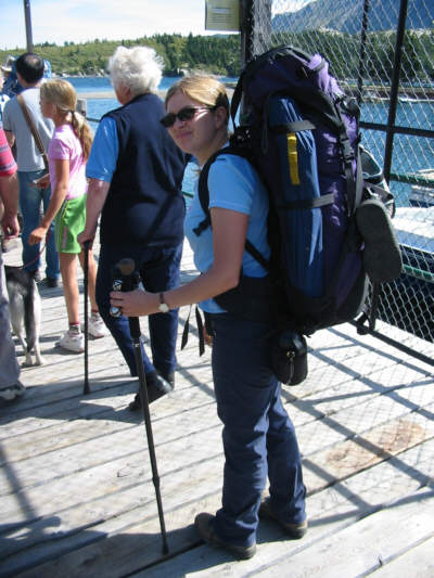
Kelly waits to board the tour boat at the Waterton marina. |
|
|
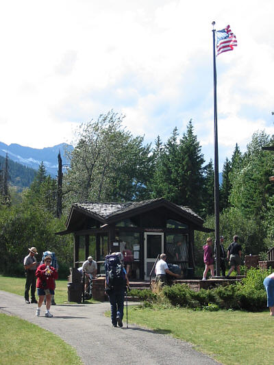
This is the Goat Haunt Ranger Station. |
|
|
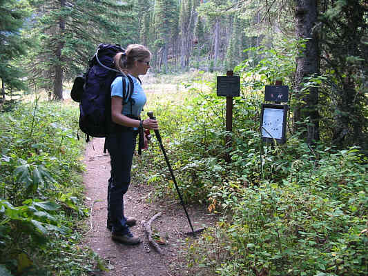
Kelly studies the informative map at the Kootenai Lake campground. |
|
|
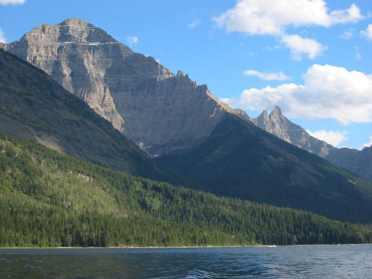
A colourful sky hangs over the largest of the Kootenai Lakes. |
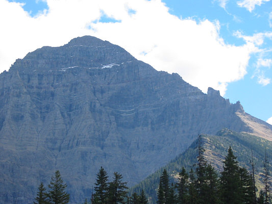
Beyond the intersection, the beaten path I followed was initially still relatively easy to hike. Being within earshot of the bubbling creek was also somewhat reassuring. If all hell broke loose, at least I wouldn't be thirsty! As I gradually gained elevation, hell was slowly breaking loose as I began encountering taller thimbleberry bushes, thicker alder trees, and increasingly more deadfall. The route I chose deteriorated into the worst bushwhack of my life, bar none. No place could use a prescribed burn (or even a non-prescribed one) more than the lower west slopes of Mount Cleveland. Deadfall blocked virtually every easy avenue of ascent, and the thimbleberry bushes, though not much of an impediment in themselves, effectively hid nasty, ankle-breaking surprises underfoot. Going through (yes, through) the alder trees was akin to climbing a StairMaster on the rolling deck of a ship in a heavy storm with a multitude of unseen arms trying to pull me down (yes, a rather whacky analogy). Quite often, upward progress could only be made by grabbing two higher branches and desperately pulling myself up while my feet were precariously balanced on two lower branches. There was much stumbling about and even a healthy dose of profanity. Every once in awhile, I would try to gauge my proximity to tree line (my salvation out of this hell hole) by looking toward Citadel Peaks across the valley. Turning back to look up Mount Cleveland, I would be both disappointed and dumbfounded by the seemingly endless sea of vegetation that still lay ahead of me. Oh, how I longed for a nice long slope of treadmill rubble! Somewhere further up, I came upon a large patch of huckleberry bushes. Though eating a few berries did not really energize me, doing so provided a small psychological boost as I fondly recalled happier times feeding on berries elsewhere. Coming across some fresh bear scat later on also reinvigorated me, and I steadily pushed on higher with some added yodeling.
After nearly three hours of sustained bushwhacking, I finally cleared tree line only to realize that I was much further north of where I should have been. To get back on track, I traversed southward and dropped into the basin below the obvious waterfall coming down the first rock band (see Kane's route photo). I then hugged the bottom edge of the same rock band before scrambling up a series of steep gullies. One of these gullies proved to be rather dicey to ascend, and at one point, I was stemming up a shallow corner with my back against a wall, my feet clinging to tenuous micro-ledges, and my right elbow jammed in a crack. After that gully, I escaped to easier terrain on climber's right just as Kane had done and continued up the normal route. The remainder of the ascent up the west face was fairly straightforward but deceptively long. I encountered one snow patch on the route and made the mistake of going straight up rather than trying to circumvent it. I had to laboriously chop steps in the hard packed snow in order to get good footing, and it took me nearly twenty minutes to gain maybe ten metres. When I finally reached the plateau atop the west face at about 3:30 PM, I was too exhausted to admire the spectacular panorama unfolding around me. I staggered up the final gentle scree slope and reached Mount Cleveland's summit at 3:59 PM.
The prospect of a long and difficult descent limited my summit stay, and I was on the move again by 4:17 PM. Other than an awkward glissade down the aforementioned snow patch, my descent down the west face was surprisingly easy. When I returned to the gullies I had ascended earlier, I stayed out of them and stuck to easier terrain on skier's left. I found a good stretch of scree surfing and continued descending a big avalanche slope toward what looked like a nice grassy valley to the south. As I got closer to the valley bottom, I realized with growing dread that what I thought was grass was actually a veritable carpet of six-foot high alder trees. Thus began the bushwhack from hell--part two. Although this thrash through the alder trees was not nearly as long or as difficult as my ascent route, I was quite frazzled at this point and felt some urgency to at least reach Camp Creek before the approaching darkness made navigation in the thick bush impossible.
When I finally stumbled onto Camp Creek, I found a large cairn nearby but couldn't find a trail or beaten path leading off anywhere. Rather than waste time trying to find "The Old Elk Trail", I simply headed downstream. Initially, I could stay in the creek bed rock-hopping from one side to the other, but increasing amounts of deadfall and some impassable waterfalls eventually forced me into the trees. I stayed mostly on the south bank, and although deadfall was still a nuisance here, the bushwhacking wasn't as terrible as I had anticipated (or maybe I was just getting used to it).
What a great relief it was to see the bridge over Camp Creek! I
strolled into the campground at about 9:00 PM to find Kelly chatting with
a guy from Australia and a girl from Ireland. I decided to forego
dinner that night (so did Kelly). Instead, I crawled into our tent,
changed out of my stinky clothes, and went to sleep with nightmares of
the horrendous bushwhacking I had endured that day.
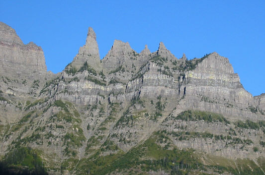 |
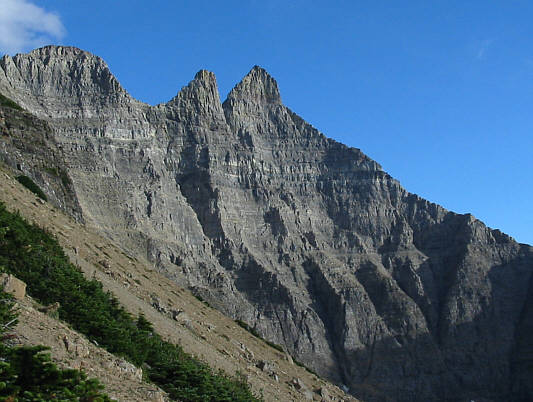
Citadel Peaks look particularly striking from the western slopes of Mount Cleveland. |
 |
This is looking west from where Sonny regained the correct route up Mount Cleveland. At centre are Kootenai Lakes while Camp Creek can be seen at lower left. |
 |
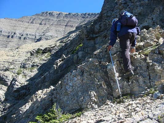
As described by Kane, this is the gully which leads "above the first and seemingly largest rockband". A less problematic route exists to the right of this gully. |
 |
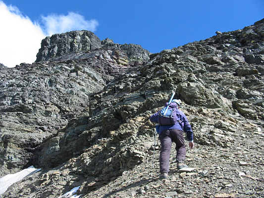
Sonny traverses toward the middle of the west face. The summit is visible in the distance but is still far away. |
 |
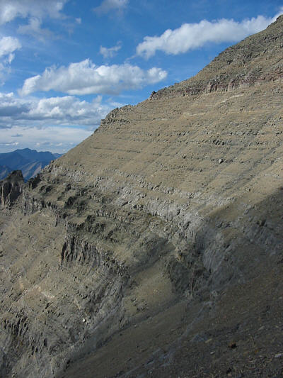
This is typical terrain on the upper part of the west face. |
 |
After reaching a broad plateau, Sonny staggers toward the summit which is still a considerable distance away. |
 |
Sonny sits on the 3190-metre summit of Mount Cleveland. |
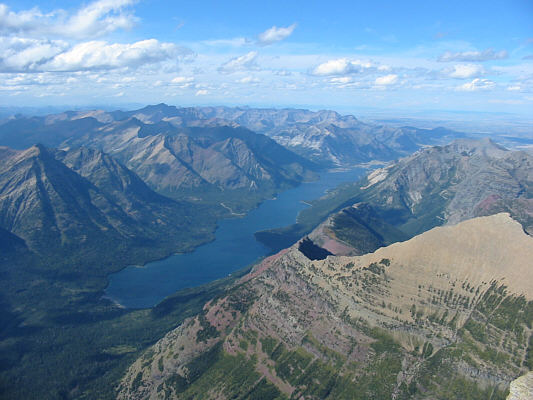 |
Upper Waterton Lake garners a lot of attention in this view to the north. At bottom right is Goat Haunt Mountain (2634 metres). |
 |
To the west, Kootenai Lakes are visible at lower left. The turquoise gem at centre is Lake Frances, and behind it on the horizon are Kintla Peak (3079 metres) and Kinnerly Peak (3031 metres). |
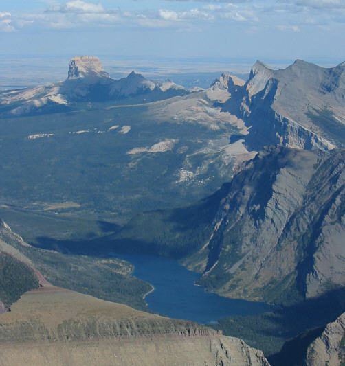 |
The view to the east includes Chief Mountain (2768 metres) and Cosley Lake. |
 |
Here is another look at Mount Cleveland's west face where five young men were swept to their deaths by a huge avalanche in December of 1969. |
 |
This snow patch is tricky to ascend and descend without crampons. |
 |
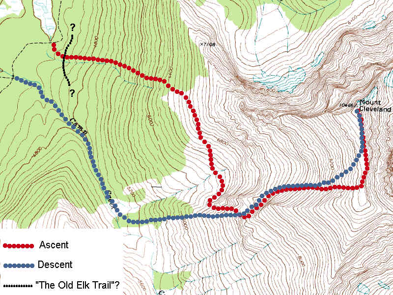
South of Mount Cleveland are the equally striking Stoney Indian Peaks (2850 metres). Click here to see a map of Sonny's approximate route of ascent and descent. |
Kelly and I had lots of time before our five-o'clock boat arrived, so we
squeezed in a couple of short easy hikes to Goat Haunt Lookout
(worthwhile) and Rainbow Falls (disappointing). At Goat Haunt
Ranger Station, the same ranger congratulated me for successfully
climbing Mount Cleveland, and I briefly described my horrible
bushwhacking experience much to his amusement. Kelly and I then
dropped our packs near the boat dock and relaxed for the next couple of
hours before the M.V. International picked us up for our return
trip to Waterton. Dinner at New Frank's Restaurant followed by ice
cream desserts (another New York cherry cheesecake waffle cone for me)
capped off a successful weekend outing.
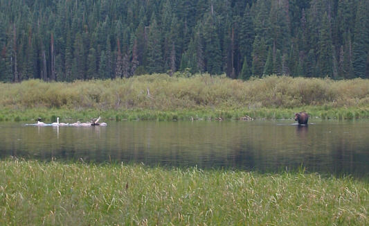 |
Some swans and a moose frolic in the lake
near the campground in the morning. Photo Courtesy of Kelly Wood |
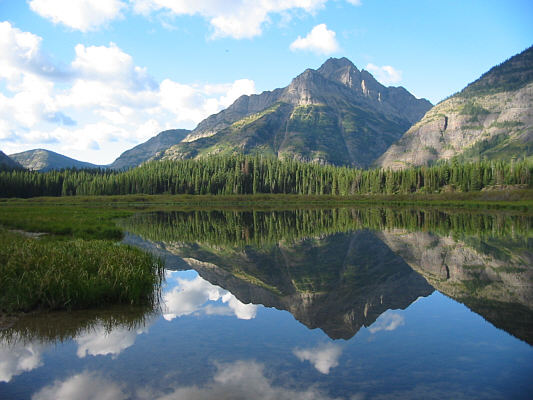 |
Kootenai Peak (2604 metres) is reflected in its namesake lake. |
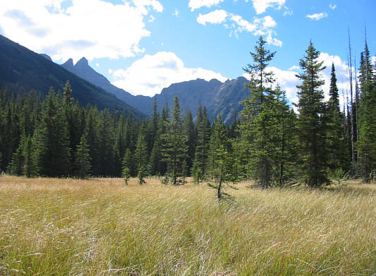 |
A mysterious cairn on the main trail seems to suggest that "The Old Elk Trail" possibly starts somewhere at the far edge of this grassy fen. |
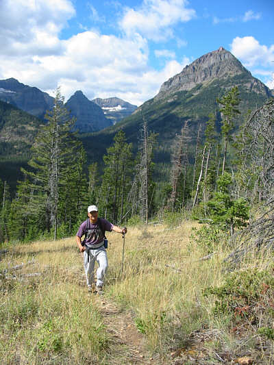 |
Sonny hikes up the trail to Goat Haunt Lookout. At right is Olson Mountain (2412 metres). |
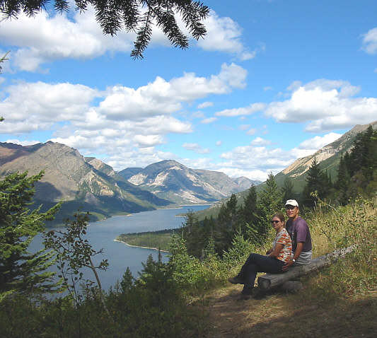 |
This is the view of Upper Waterton Lake from Goat Haunt Lookout. |
 |
This sign is very reassuring to hikers who might not know when to stop. |
 |
Rainbow Falls |
 |
A small clearing not far from Rainbow Falls allows this glimpse of Mount Cleveland's north face which is apparently the biggest vertical wall in the continental United States (ie. "Lower 48"). |
 |
Kelly relaxes near the boat dock at Goat Haunt. Across the lake is Campbell Mountain (2513 metres). |
 |
Sonny is eager to board the tour boat and return to Canada. |
 |
Here is one last look at Mount Cleveland from the stern of the M.V. International. |