BOU AVENUE
Windy Viewpoint And Pigeon
Mountain Ski Resort
On 20 February 2021, Zosia Zgolak and I did
a ski tour of Windy Viewpoint and the defunct Pigeon Mountain Ski Resort
(PMSR)
in Alberta's Bow Valley Wildland Provincial Park. Windy Viewpoint
is the east end of Wind Ridge and shares the same approach trail as
described in Gillean Daffern's Kananaskis Country Trail Guide.
Both Zosia and I have hiked up Wind Ridge separately in the past, but
neither of us had ever tried it on skis or visited Windy Viewpoint.
Knowing that there is some scrambling involved in reaching the top of
Wind Ridge, I was already doubtful about the prospect of skiing all the
way up, but Windy Viewpoint would make a good consolation prize
regardless. Our plan was to also ski up and down nearby PMSR if we
had extra time and energy. I have long been curious about the
reclaimed ski runs of PMSR which I see every time I drive home from the mountains
along Trans-Canada Highway, and I am certain that skiers still frequent
the slopes whenever there is a fresh dump of snow. The
resort's history and demise is featured in this interesting Calgary
Herald
article by Michele Jarvie.
Starting from the Pigeon Mountain Day Use area (south of Dead Man's Flats
at the end of George Biggy Sr. Road just before the entrance to Banff
Gate Mountain Resort), Zosia and I skied past the turnoff to Skogan Pass
and followed the signed trail to Windy
Viewpoint. The snow-covered trail was well-packed mostly from foot
traffic, but we did see some old ski tracks as well. On the way in,
we took the hikers' trail which was re-routed with new bridges after the
biblical floods of 2013. We had no problems skiing this section,
but the trail undulates a fair bit with all the creek crossings.
Once we merged with the equestrian trail, we settled into a long and
gradual climb, first along West Wind Creek and then up the east end of
Wind Ridge. There is a large section of Wind Ridge that has an
annual closure from December 1 to June 15 to protect important
bighorn sheep habitat, but fortunately, the trail skirts around the
perimeter of this closed area and is still open year-round. Where
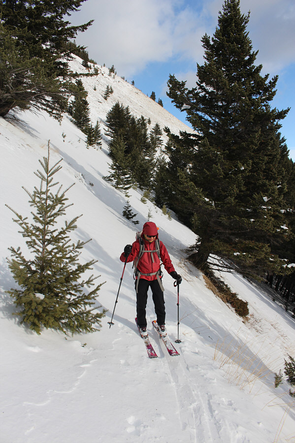
the trail emerges from the forest onto steep open slopes, we ran into
some wind-affected snow which was a bit tricky to ski on. We donned
our ski crampons here to give us better purchase on the icy snow, and
even then, it was not easy to traverse the covered trail. More alarmingly,
we noticed some instabilities in the snow pack here including one
sizeable and loud fracture. Although I did not think there was
enough snow here for a slide to become deadly, we quickened our pace a
bit to get to safer ground. Once we were clear of the danger zone,
we climbed a little higher before reaching the next steep section of
trail that was largely snow-free. We ditched our skis here and
boot-packed uphill to the juncture between the routes for Wind Ridge and
Windy Viewpoint. By this point, we had pretty much given up on
climbing Wind Ridge. The remainder of the route up the ridge was
snow-covered and steep, and the snow was likely wind-blown and prone to
avalanche especially in light of the fracture we encountered earlier.
Neither of us felt it was worth the risk, and instead, we were quite
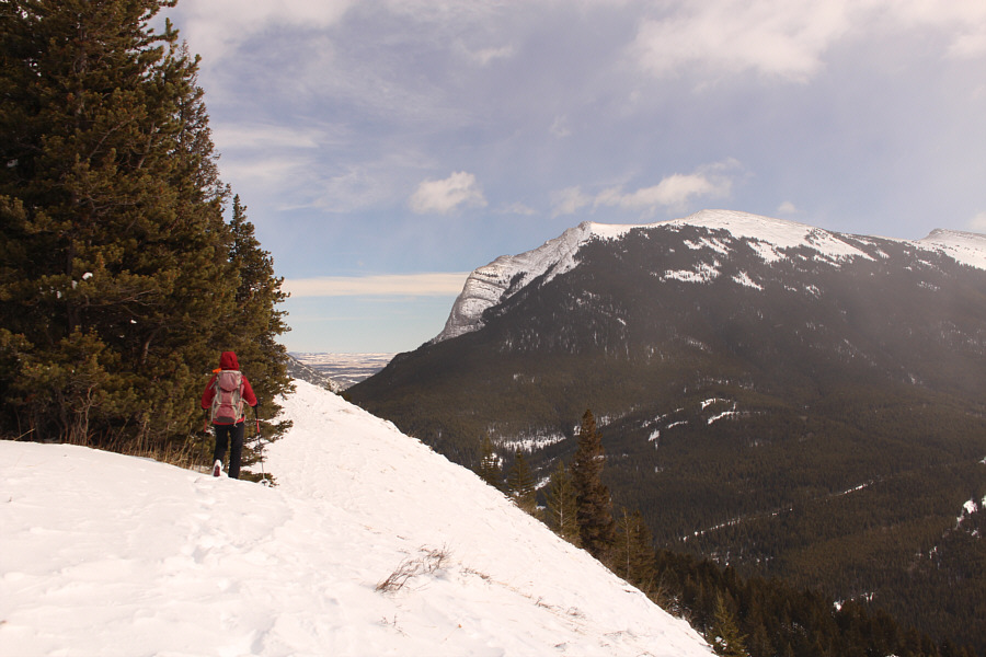
content to hike up the much safer route to Windy Viewpoint. Indeed,
Windy Viewpoint lived up to its name as we were treated to some great
views while being buffeted by the occasional wind gust. Roughly
fifty metres to the north is a more sheltered viewpoint, and we stopped
here for a nice lunch break out of the wind.
For our descent, Zosia and I retraced our
steps back to where we ditched our skis. We then cautiously skied
back across the problematic section we traversed earlier, and fortunately,
the snow remained unreactive this time. The forested slopes of Wind
Ridge
are not conducive for skiing as there is too much deadfall and not enough
snow, and consequently, we were forced to ski back down the trail which
was a bit of an adventure given the choppy conditions.
We snowplowed a lot of the steep upper half of the trail which proved to
be quite tiring, and it was not until we reached the turn along West Wind
Creek that we were finally able to relax on the more gentle lower half of
the trail. To avoid the unnecessary undulations along the hikers' trail, we opted to take the slightly longer
equestrian trail on the way back. We encountered a bit more
deadfall on this trail, but otherwise, it seemed to be a smoother ski
with less abrupt dips. After merging again with the hikers' trail,
we returned to the turnoff to Skogan Pass to begin the second half of our
ski tour.
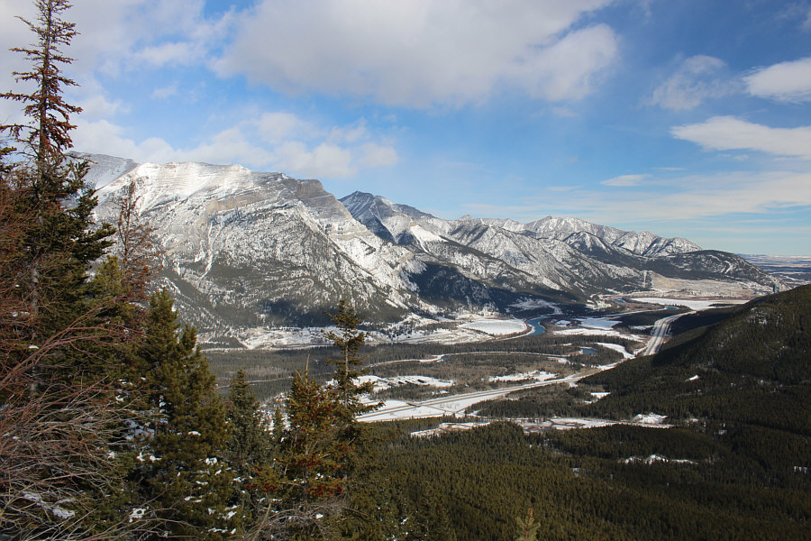
Pigeon Mountain dominates the view to the east. The remnants of
the ski resort runs are still visible.
 |
The view to the south includes the four peaks of
Mount Lougheed
and Windtower. |
 |
Rimwall Summit,
The Orphan and Wind Ridge round out the view to the southwest. |
 |
After retrieving her skis, Zosia carefully skis back down the trail. |
 |
The ski back down the trail unfortunately entails a lot of snowplowing. |
 |
While descending the less maintained equestrian trail, Zosia demonstrates
an unusual technique for getting over downed trees. |
While it would have made more sense to skin up the reclaimed
ski runs of PMSR, for some reason I had it in my mind to climb partway up
the trail to Skogan Pass and then bushwhack the remaining distance to the
top of the resort. As Zosia and I would quickly learn, this was a
grave miscalculation made even worse when we left the trail on the wrong
side of notable gully on the lower west slopes of Pigeon Mountain.
The forested slopes here are littered with deadfall, and although we
could still climb over and around much of it, the whole endeavour felt
quite tedious and unpleasant. The worst part was realizing too late
that we were on the wrong side of the aforementioned gully which has
steep embankments and is choked with more deadfall. Unable to find
an easy way across, we ultimately had to bite the bullet and dive into
the tangled mess of snow-covered logs in the gully before removing our
skis and squirming up the other side through deep sugary snow.
Travel was easier once we cleared the gully, and we eventually worked our
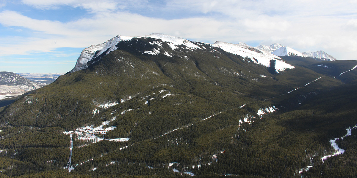
way to the top of the ski resort which is marked by a concrete foundation
and a small cairn. Numerous old tracks in the snow confirmed my
suspicion that people still come here regularly to ski these slopes.
After removing our climbing skins, Zosia and I skied down the reclaimed
runs of the resort. Some of the runs on the upper half of the
resort are still wide open while most of the lower runs are now being
slowly choked by shrubs and forty-year-old trees. Overall, the
skiing was passable if not great mostly because a lot of the skiable
areas were already tracked out by other backcountry enthusiasts. It
would be interesting to return here immediately after the next big snow
storm. To avoid cutting through Banff Gate Mountain Resort near the
bottom, we traversed to skier's left and entered forest for another round
of dodging deadfall. Thankfully, this second round was short-lived,
and we were soon skidding into the day use area parking lot to wrap up
our ski tour.
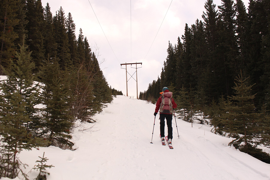 |
Zosia climbs up the power line right-of-way which ultimately leads to
Skogan Pass. |
 |
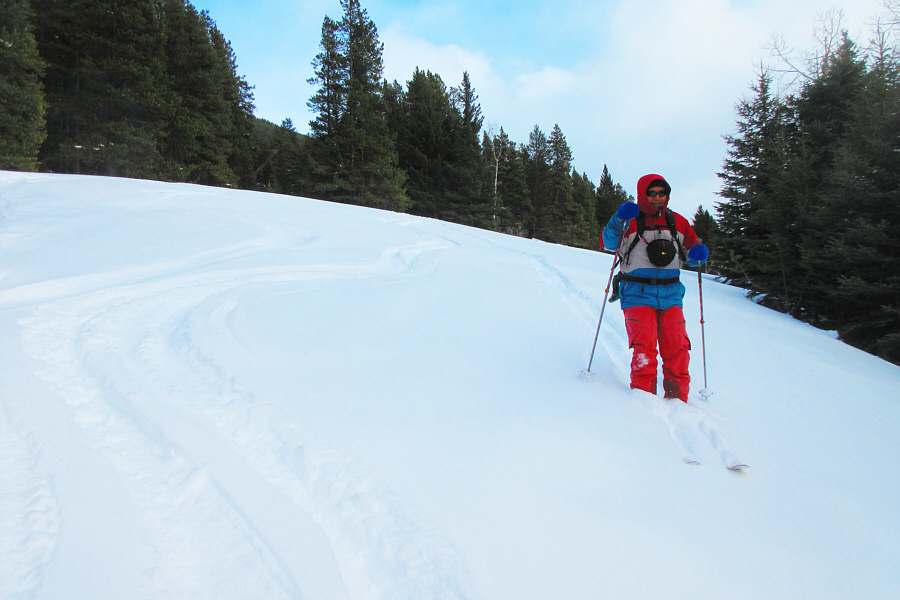
After leaving the trail to Skogan Pass, Sonny encounters some difficult
ski terrain on the lower slopes of Pigeon Mountain.
Photo courtesy of Zosia Zgolak |
 |
Zosia inspects some mysterious claw marks on this tree. |
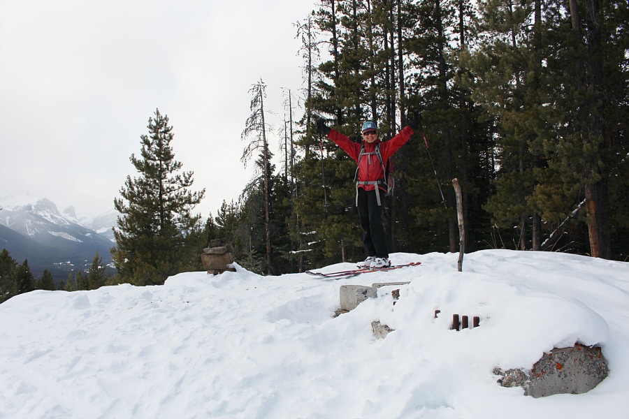 |
Zosia reaches the top of Pigeon Mountain Ski Resort (1656 metres). |
 |
The cairn at the top of the resort has a profound message. |
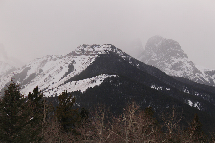 |
This is looking across the valley to Wind Ridge and Little Sister (right)
from the top of the resort. Windy Viewpoint is visible in front of
and below Wind Ridge. |
 |
Zosia descends a wide open run that
has not yet been reclaimed. |
 |
Sonny cruises down the wide open run.
Photo courtesy of Zosia Zgolak |
 |
Zosia weaves her way between trees on
a ski run that is slowly being reclaimed. Plenty of old tracks
here show that people still frequent these slopes. |

Sonny approaches Banff Gate Mountain Resort near the
bottom of the ski run..
Photo courtesy of Zosia Zgolak
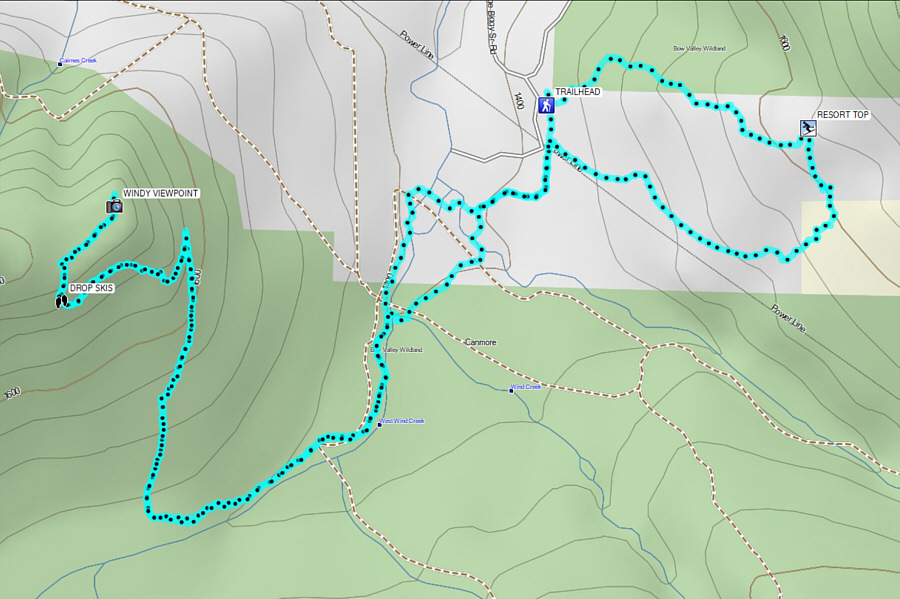 |
Total
Distance: 14.9 kilometres
Round-Trip Time: 7 hours 44 minutes
Cumulative
Elevation Gain: 775 metres
GPX Data |