


Linda Breton and I initially planned on bagging Chief Mountain by ourselves after she responded to my rather whimsical proposal in my Mount Cleveland trip report. After much researching, e-mailing, and discussions on the Rocky Mountain Books WebForum, we would eventually be joined by Bill Kerr, Bob Parr, Gary Vandergrift, and James Yearous. Before the trip, Linda and Bill both tried to find out where we could get the aforementioned permits, and in the end, Bill settled on buying two rather expensive fishing licenses (which include the land access permits) to be picked up in Cardston, Alberta.
On 16 October 2005, Bob joined Linda and me at my place at 4:30 AM, and we piled into my car and drove to Fort Macleod, Alberta to pick up James and rendezvous with Bill and Gary. We then drove in two cars (mine and Bill's) to the Husky gas station in Cardston where Bill picked up his prepaid fishing licenses while Linda browsed the station's soda pop section to find out the difference between Diet Coke and Coke Zero. Our next stop in the journey was at the Carway-Peigan border crossing (open 07:00-23:00 all year). Although Bill looked suspicious enough to have his car briefly searched, we generally had no problems entering Montana (only photo ID's were required). The sky began to lighten as we neared Chief Mountain, and we were dismayed to find so much cloud cover in the area. Raindrops were also pelting my windshield, but more disturbing was the strong wind buffeting my car.
About 16 kilometres south of the border, we turned right onto Chief Mountain Highway and drove for another 16 kilometres before turning left onto the Humble Oil Company road (not signed but fairly obvious). Except for a few rough spots, the road leading to the north side of Chief Mountain was in surprisingly good shape. A two-wheel drive car could probably make it as far as a large clearing where a much rougher dirt track (four-wheel drive and good clearance required) climbs the last few hundred metres to the trailhead on top of a low ridge. Despite grumblings (mostly from me) about the cold temperatures and the fierce wind, we all geared up and started hiking up the trail by 8:31 AM.
After hiking through some scrubby forest and passing some small ponds (a decidedly ugly area despite the natural features), we worked our way up a moraine-like slope and crossed a large grassy meadow to a boulder field near the base of Chief Mountain. Picking our way through the boulder field was tedious enough, but the intensifying wind was starting to hamper our progress as we rounded the west end of the mountain. Here, the terrain is a hodgepodge of loose, rotten rubble and house-sized boulders threatening to topple over much like seracs in an icefall. There are also deep fissures here not unlike crevasses on a glacier which require some care to negotiate. The gale force wind absolutely pounded this end of the mountain making walking quite difficult at times. We all lamented not bringing ski goggles along as snow and dust stung our faces.
Thankfully, the wind abated somewhat once we got around to the southwest slopes, but now we faced a lengthy grovel up treadmill scree. A notch in the summit ridge is the key to reaching the top, but because of the foreshortened view, we had some difficulty figuring out where this notch was from below. The group became separated here with most of the guys pushing forward to try and find the notch while Linda and I struggled to keep up. I was higher up the slope than Linda when I noticed the others traversing across the slope to the right below the summit cliffs. I promptly angled up to follow the guys and eventually found them huddled just below the notch for a break out of the wind. I waited a short distance below them in hopes that Linda would catch sight of me, and at one point, I saw her pop above a rock band. I waved to her, but she then disappeared below the same rock band. At this point, most of the others had continued up to the summit ridge, but thinking that Linda was still on her way over to me, I waited...and waited...
Suddenly, I saw Linda's unmistakable red jacket further down the slope. She was descending. A little dumbfounded, I turned and headed up to the notch. Despite a couple of moderately exposed down-climbs, I had no real difficulties scrambling along the enjoyable summit ridge. The wind wasn't even that bad up there. I soon joined the rest of the guys at the summit at 12:47 PM.
With limited views and cool conditions, there was little point in lingering at the summit, and we were all on our way down by 1:03 PM. Our return trip was unremarkable except for an animal sighting that Bob and I made in the boulder field on the north side of the mountain. I initially detected some movement out of the corner of my eye, but when I focused my attention, all I saw was rocks and shadows. Believing that my mind was playing tricks on me, I asked Bob, who was nearby, if he saw anything. Shortly after, we both saw a pure black shape about the size of a large dog bounding away from us and disappearing under some Krummholz. Bob thought it was either a marmot or an otter while I thought it was a puma. When we rejoined Linda at the ponds and described to her our close encounter, she made the astute observation that the animal was possibly a wolverine.
We all made it back to the trailhead by 3:45 PM and were quite relieved to be finally in our cars and out of that miserable wind. At the border crossing, the Canadian customs agent gave me a slightly harder time than his American counterpart when he asked me, and only me, for proof of citizenship. I was a little put off that I was singled out, but I must have looked pretty crazy with my tousled hair and blood-shot eyes (from the wind and dust). Despite Bill's and Gary's preference for beer and wings, we all settled on a rather bad Chinese buffet dinner in Cardston before heading home.
Incidentally, Linda turned around before the summit because she "had surpassed [her] suffering threshold". Given the crappy weather, I could hardly argue against that, but I still feel bad that she didn't make the summit. Hopefully, she will make a return trip and complete the climb in more favourable conditions. Next year?
Check out Linda's trip report
here and
Bill's photos here.
|
|
It is already quite windy at the trailhead. From L to R are Gary, Linda, Bob, James and Bill. |
|
|
Bob pauses to survey the devastated landscape north of Chief Mountain. According to Edwards' guidebook, the entire northeast corner of the mountain collapsed on 31 July 1972. |
|
|
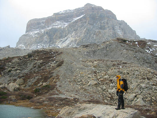
As they get closer to Chief Mountain, everyone tries to take shelter from the relentless wind. |
|
|
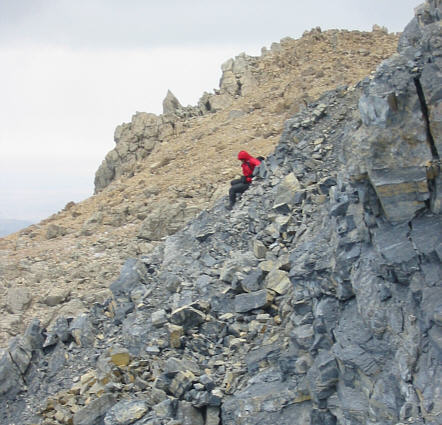
James works his way down a big crack at the west end of Chief Mountain. Linda (red spot) is barely visible at far left. |
|
|
The wind knocks Linda off balance for a few tense moments. |
|
|
After rounding the west end of the mountain, the group traverses below some cliffs to get to the southwest slopes. |
|
|
This is looking up the huge scree slope on the southwest side of the mountain. The key to gaining the summit ridge is finding the notch (N). |
|
|
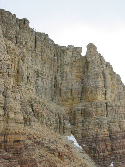
Here is a closer look at the cliffs guarding the summit ridge. Note the figures traversing below the dark rock bands at left. Access to the notch is gained by climbing up behind these same bands. |
|
|
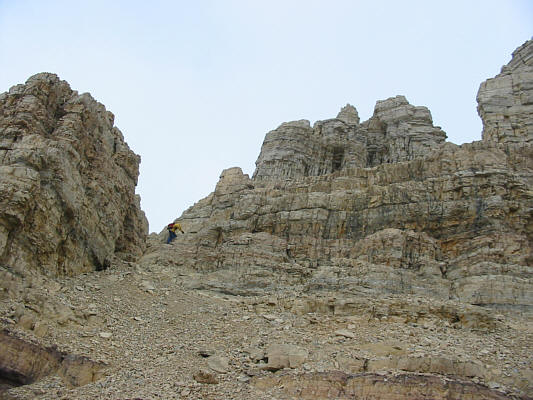
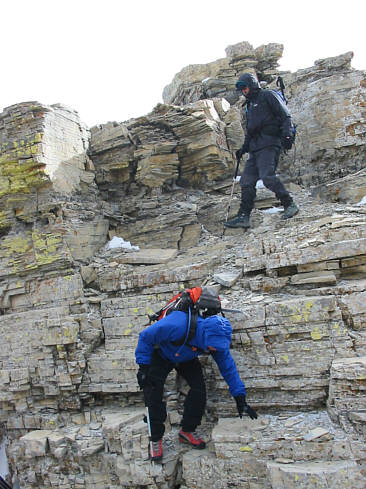
James scrambles up some easy rock steps at the notch. |
|
|
Here is an even closer look at the summit cliffs. Note the figures at top left. |
|
|
This is the summit ridge of Chief Mountain. |
|
|
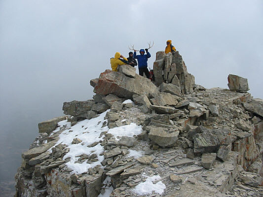
Some rock slabs at the summit provide good shelter from the wind. That's Bill goofing around with the summit antlers. |
|
|
On the 2760-metre summit of Chief Mountain are (L to R) Bob, James, Bill, Gary, and Sonny. |
|
|
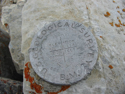
This is the survey marker at the top of Chief Mountain. Edwards' book lists the elevation as 9080 feet while this marker lists it as 9056 feet. |
|
|
This is looking down from the summit at the devastation resulting from the 1972 collapse. |
|
|
Bill (bottom) and Gary descend into one of the gaps along the summit ridge. |
|
|
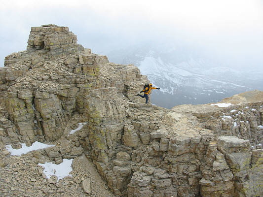
Bob does his best impression of a wind vane. |
|
|
Gary descends into the notch on his way down. |
|
|
The group descends the huge scree slope. |
|
|
To the west is the spectacular pinnacle known as Squaw Mountain. |
|
|
Gary works his way back around to the north side of Chief Mountain. |
|
|
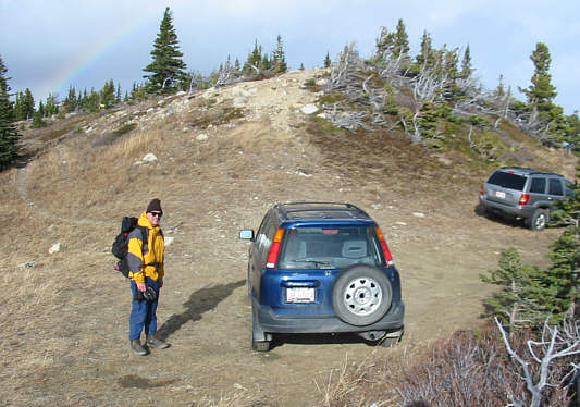
Bob is the first to get back to the trailhead. Note the rainbow at upper left. |