BOU AVENUE
Packsaddle Mountain
The old adage that the journey is more important than
the destination would aptly describe my adventure on Packsaddle Mountain,
a rather obscure peak on the eastern shore of Lake Pend Oreille in the Idaho
Panhandle. The day after climbing
Leatherman Peak,
I drove north from Challis in central Idaho and eventually cut through
Montana to get to Coeur D'Alene. From there, I continued north to
Sandpoint and ultimately ended up in Clark Fork, a small town situated where its
namesake river drains into Lake Pend Oreille. Having consulted Tom Lopezs Idaho: A Climbing Guide,
I made plans to hike up Scotchman Peak which is located about 8.5
kilometres northeast of Clark Fork. Arriving at nightfall, I crossed the bridge on the south
side of town and
briefly drove along the Pend Oreille Shore Road (FS-278) looking for
places to camp. Finding myself getting further and further away from
town, I turned around and headed back through Clark Fork with the
intention of camping at the trailhead for Scotchman Peak. Everything was going smoothly until I ran into a roadblock a
few kilometres up the access road. A notice on the
roadblock stated that the area surrounding Scotchman Peak was closed due
to fire danger. Disappointed at the turn of events, I consulted
Lopezs book and my Idaho recreational map to find a Plan B. Plan B
ended up being Packsaddle Mountain which is located about 18.6 kilometres
southwest of Clark Fork. I
turned my car around and drove back through town and across the
river to FS-278. This time I drove farther until I
reached a fork in the road where there appeared to be another roadblock. Initially, I thought that the left-hand fork was closed;
consequently, I turned down the right-hand fork which quickly ended at a parking
lot near a boat launch (Derr Creek). I made a mental note about
possibly camping here if I could not find a more suitable spot.
With access to Packsaddle Mountain seemingly closed just like Scotchman
Peak, I was out of ideas and ready to just move on. I drove back to
Clark Fork with intentions of backtracking all the way to Coeur D'Alene
to sleep at a rest stop on the I-90. As I entered the town for the
umpteenth time, I felt thirsty and decided to stop at a convenience store
to get a drink. While browsing the store, I happened to find an
Idaho Panhandle Forest Service map which has an amazing amount of detail
regarding the local forestry roads and trails. At first, I was
reluctant to purchase the map for $12 USD since I was leaving the area
anyway, but when I went to pay for my drink, I noticed on the cashier's
counter a recent fire closure map which was derived from
the same Forest Service map I was just perusing. As I studied the
fire closure map, I realized that only the eastern access for Packsaddle
Mountain was closed. The summit was not in
the closure zone and could still be accessed by alternate approaches from
the west along FS-278. What confused me though was the roadblock I
encountered back at the fork. Curiosity got the best of
me, and I added the Forest Service map to my purchase. I even asked
the cashier if I could take the fire closure map. She was a little
hesitant at first since it was the only copy she had left, but I think
she eventually relented since I was a paying customer!
After
studying the maps at length in my car outside the convenience store, I
drove back to the fork, and this time I noticed that the "roadblock" was
actually positioned such as to allow traffic to continue and to also draw
attention to the closure of Monarch Ridge Road (FS-1066) which branches
off from FS-278 further up and leads to the eastern access for Packsaddle
Mountain. I continued driving along FS-278 not only to check out
the western accesses for Packsaddle Mountain but to also find a
campground (Whiskey Rock) which is located on the eastern shores of Lake Pend Oreille. Driving unfamiliar logging roads is bad enough during
the day, and I might have been a bit insane to go exploring them in the
night. However, armed with the Forest Service map, I felt confident
about negotiating the maze of roads in the area. FS-278 is a wide
and relatively well-maintained gravel road which is easy to follow, but
it is very windy with lots of ups and downs. I stopped at every
signed junction to verify my position on the map, and it seemed to take
an inordinately long time to make any progress along the road. I
eventually passed the turnoff (Falls Creek Road) that leads to the
trailhead for Minerva Ridge which is one of the western approaches for
Packsaddle Mountain. Since it was too dark to investigate the
trailhead, I continued driving for about another 4 kilometres before I
reached Whiskey Rock campground (pit toilets, picnic tables, fire rings,
no fees). The campground was, perhaps not surprisingly, deserted,
and it felt a little creepy at first. The feeling passed soon
enough especially when I realized that I still had cel phone reception
way out here. I posted my location on Facebook before drifting off
to sleep.
Unfortunately, my sleep was disturbed throughout the
night by some rascally rodent skittering about under my car, and I was
not feeling as restful as I would have hoped on the morning of 2
September 2015. I took a few minutes to check out the view of Lake
Pend Oreille before leaving the campground and driving back to Falls
Creek Road. About 300 metres after leaving FS-278, I came to yet
another fork in the road. The right-hand fork is the continuation
of Falls Creek Road, but the overgrown left-hand fork supposedly leads to
the Minerva Ridge trailhead about 420 metres further. Worried about
scratching the paint on my car, I got out with my GPS and walked down the
left-hand fork to look for the trailhead. Strangely enough, the
trailhead was nowhere to be found. I walked well past where I was
expecting the trailhead to be and back again, and nowhere did I see
anything even resembling a trail along that stretch of road. The
Minerva Ridge trailhead, if it ever existed, was completely reclaimed.
The Falls Creek trail is yet another alternate access for Packsaddle
Mountain, and I briefly drove up the right-hand fork before turning
around because I was not sure if this trailhead would also be reclaimed.
Back at the fork, I tried one more time to locate the Minerva Ridge trail
by making a beeline through the bush to where I thought I would intersect
the trail. Sure enough, I found the trail as marked in my GPS, but
it was so overgrown that I immediately lost the trail as soon as I tried
to trace it back out to the road. The prospect of being able to
follow the trail up Minerva Ridge did not seem very promising, and I
dejectedly retreated back to my car.
I was ready to give up at this point when a couple
of dirt bikers came down Falls Creek Road and stopped at the fork.
I got out of my car to chat with one of them, and it turns out that they
were workers contracted by the Forest Service to help clear and maintain
trails throughout the Idaho Panhandle. They confirmed my suspicions
about the Minerva Ridge trail being largely reclaimed, but they also
informed me that the Falls Creek trail was in good shape and clear all
the way to the summit of Packsaddle Mountain which was where they had
just descended from. I thanked them for the information and
promptly drove back up the right-hand fork all the way to the Falls Creek
trailhead which was signed and obvious.
After all the effort it took to finally get to a
trailhead, the hike up Falls Creek and the summit of Packsaddle Mountain
seemed almost anticlimactic. As promised by the workers, the trail
was in excellent shape, and I was quite impressed that they were able to ride
down some sections of trail that I would have deemed impossible or crazy
for a mountain bike. Bear scat was very abundant, and I made more
noise than usual for my solo outings. Most of the trail is
forested, and only just below the summit do the trees finally thin out
and grant unobstructed views of the surroundings. I tiptoed around
the debris on the summit for a little over 20 minutes before light rain
chased me off. My return hike to my car was pleasantly uneventful.
Instead of backtracking to Clark Fork, I continued
south along FS-278 in hopes of shortening my drive back to Coeur D'Alene.
This southern portion of the Pend Oreille Shore Road is just as
long-winded as the northern portion, but I was surprised to see a fair
amount of development along the road including a resort and a luxurious
lakeside village (Cedar Creek). After driving for so long on
gravel, it felt a little odd getting back onto pavement at Bunco Corners
at the southern terminus of FS-278. I eventually drove through
Coeur D'Alene and headed west on the I-90 into Washington where I found a
nice rest area (Ryegrass) to stop for the night. Interestingly, I
had a much better sleep here beside the busy highway than I did at the much
quieter (perhaps too quiet) Whiskey Rock campground.
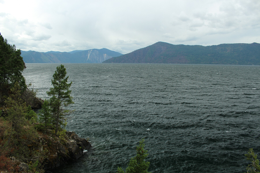 |
Looking southwest from Whiskey Rock
campground, Cape Horn Peak (right of centre) and Bernard Peak (left
of centre) are visible across Lake Pend Oreille. |
 |
The signpost marks the start of Falls
Creek trail (FST-229). |
 |
Found near a rustic camp site, these
appear to be old makeshift shelves that are being snapped as the
trees grow in size. |
 |
An AA battery gives some perspective
to the size of this bone that Sonny found on the trail. |
 |
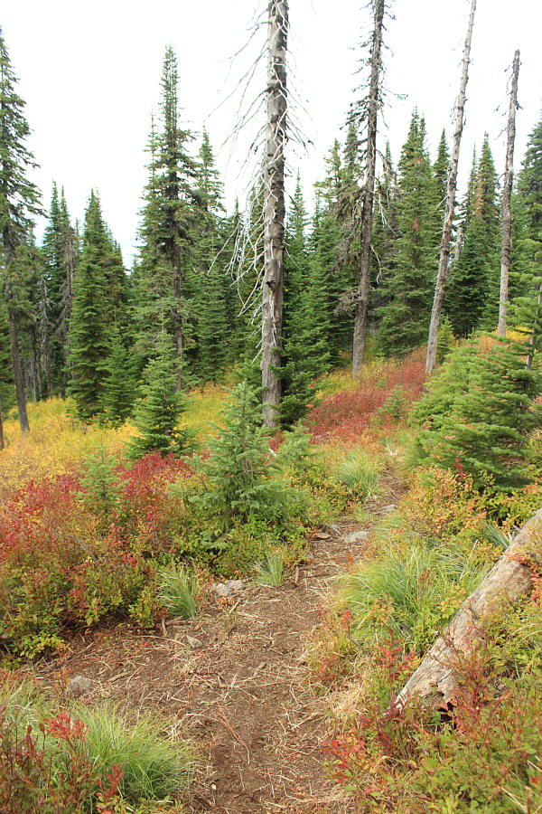
The Falls Creek trail is forested for
most of the way up Packsaddle Mountain. |
 |
This is the junction of Falls Creek
trail and Minerva Ridge trail (FST-610). |
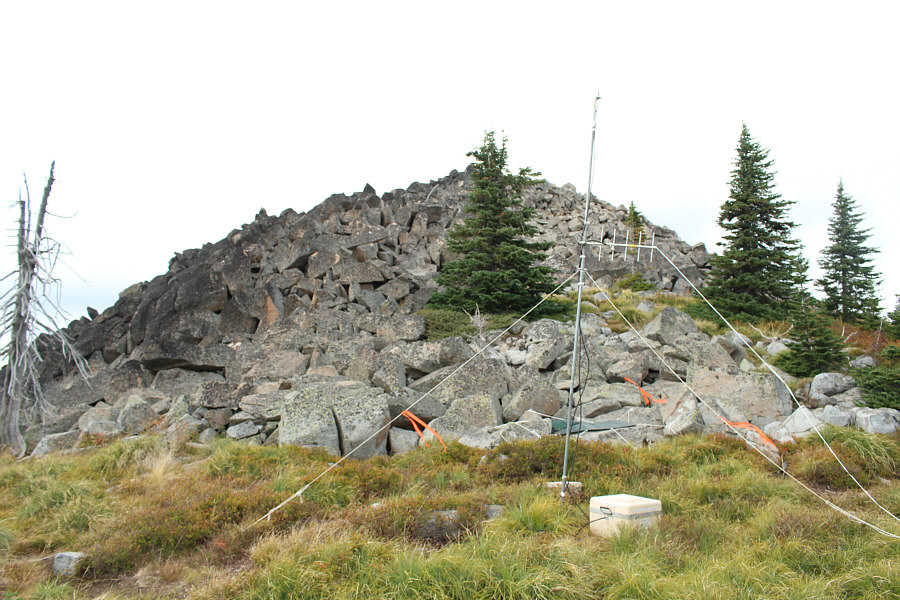 |
An antenna sits at the base of the
summit block. |
 |
Remnants of an
old lookout building
still occupy the top of Packsaddle Mountain. |
 |
Sonny stands on the 1944-metre summit
of Packsaddle Mountain. |
 |
The lower south summit of Packsaddle
Mountain is a short distance away. |
 |
In this view to the north, Minerva
Ridge can be seen in the foreground and stretching away to the left. |
 |
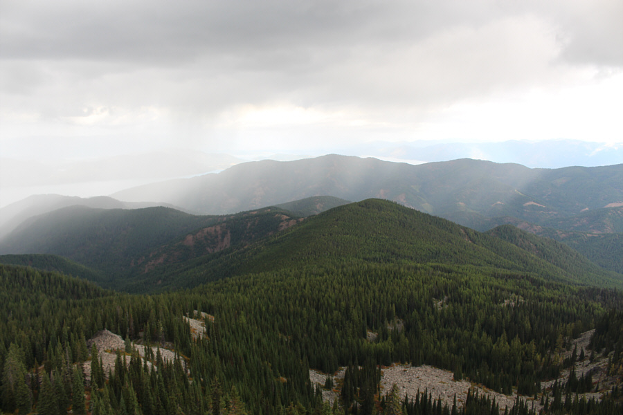
Sunbeams strike Lake Pend Oreille as
rain clouds move into the area. |
 |
There are some interesting fence
ornaments along one stretch of Pend Oreille Shore Road (FS-278). |
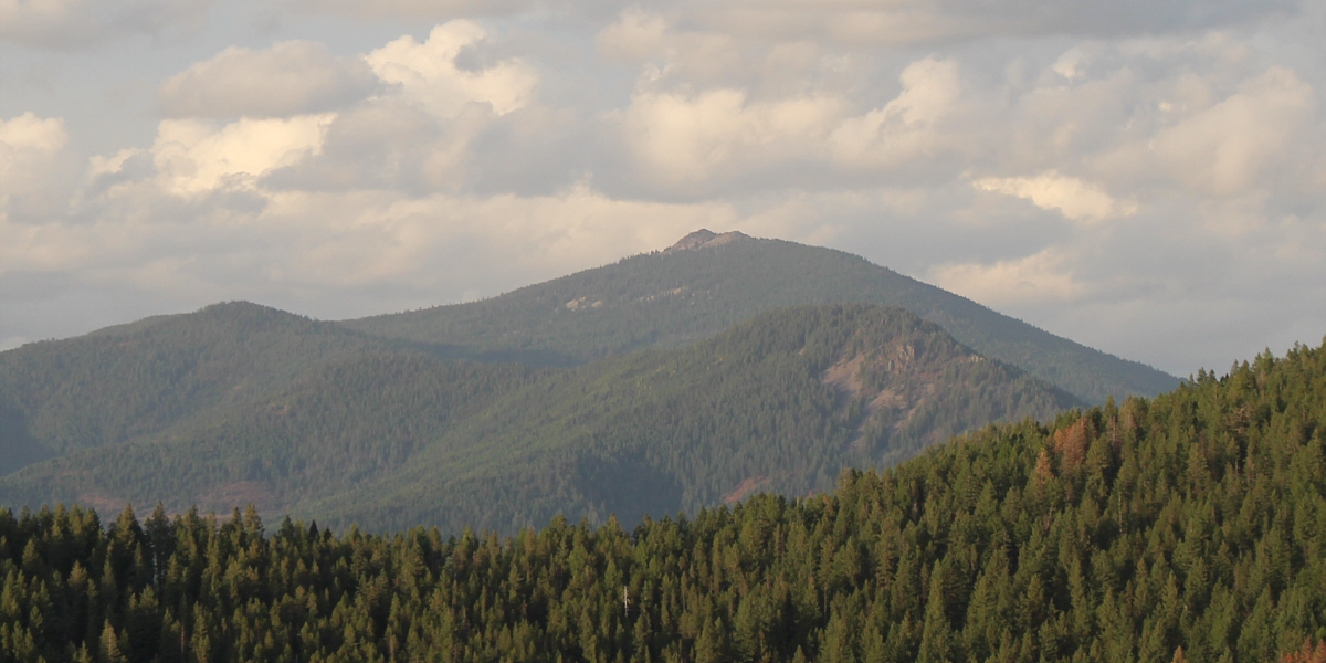
An opening along Pend Oreille Shore Road near its
southern terminus grants this view of Packsaddle Mountain.
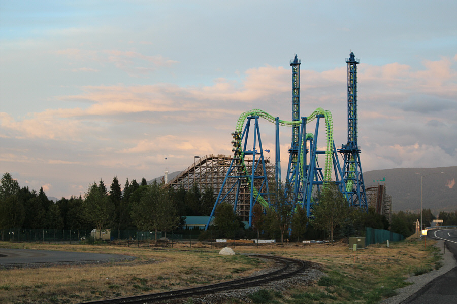 |
The Silverwood Theme Park is an
arresting sight after a full day spent in the woods of the Coeur
D'Alene Mountains. |
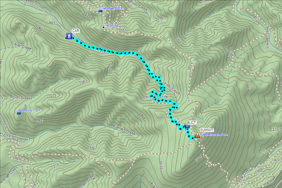 |
Total Distance: 16.9 kilometres
Round-Trip Time: 5 hours 35 minutes
Net Elevation Gain: 980 metres
GPX Data |
